


 As climate change accelerates the frequency, scale, and intensity of wildfires globally, fire management agencies are compelled to adopt smarter, faster, and more precise technologies. Drones, or Unmanned Aerial Vehicles (UAVs), have transitioned from their early roles in aerial photography to become frontline tools in wildfire intelligence, suppression support, and post-incident analysis. Their utility now spans the entire wildfire lifecycle—from pre-ignition surveillance and early detection to operational coordination during fires and comprehensive environmental assessments after containment. The widespread integration of drones into wildfire management is not only enhancing tactical situational awareness but also redefining how public and private firefighting institutions allocate resources, assess risks, and protect both ecosystems and urban settlements.
The operational adoption of drones in wildfire response first took form in the United States, notably gaining momentum post-2011 following their demonstration at the FDIC International Conference. Initially perceived as supplemental visual tools, drones rapidly evolved into indispensable wildfire reconnaissance assets. By 2018, more than 200 fire departments had integrated UAVs into their field operations, with the number growing exponentially by 2020 as real-time thermal imaging, AI-driven mapping, and high-resolution surveillance became available through compact, rugged drone systems. Drones now offer unprecedented access to dynamic wildfire data—terrain mapping, vegetation type, wind direction modeling, and infrared thermal layering—essential for forming predictive models and real-time operational planning.
In pre-fire operations, drones are proving instrumental in risk assessment and preventive strategies. Their ability to scan vast forested terrains, identify potential fuel accumulations, and monitor fire-prone zones under dry or windy conditions is revolutionizing how fire readiness is approached. Traditional aerial surveys via helicopters or fixed-wing aircraft involve high costs, limited flight windows, and operator fatigue, whereas drones offer agile, on-demand aerial intelligence at a fraction of the cost. For instance, the integration of drones with LiDAR (Light Detection and Ranging) and multispectral sensors allows fire agencies to digitally model fuel moisture levels, understory density, and ignition potential—data that are then fed into fire behavior prediction systems. Additionally, cutting-edge developments such as the University of Nebraska–Lincoln’s fire-ignition drones, which use GPS, IR cameras, and up to 400 fireballs for controlled burns, demonstrate how UAVs can safely execute prescribed burning programs without putting field personnel in harm’s way. This is of particular significance in regions like California, Australia, or central India, where controlled burns are a vital part of ecosystem health and wildfire mitigation.
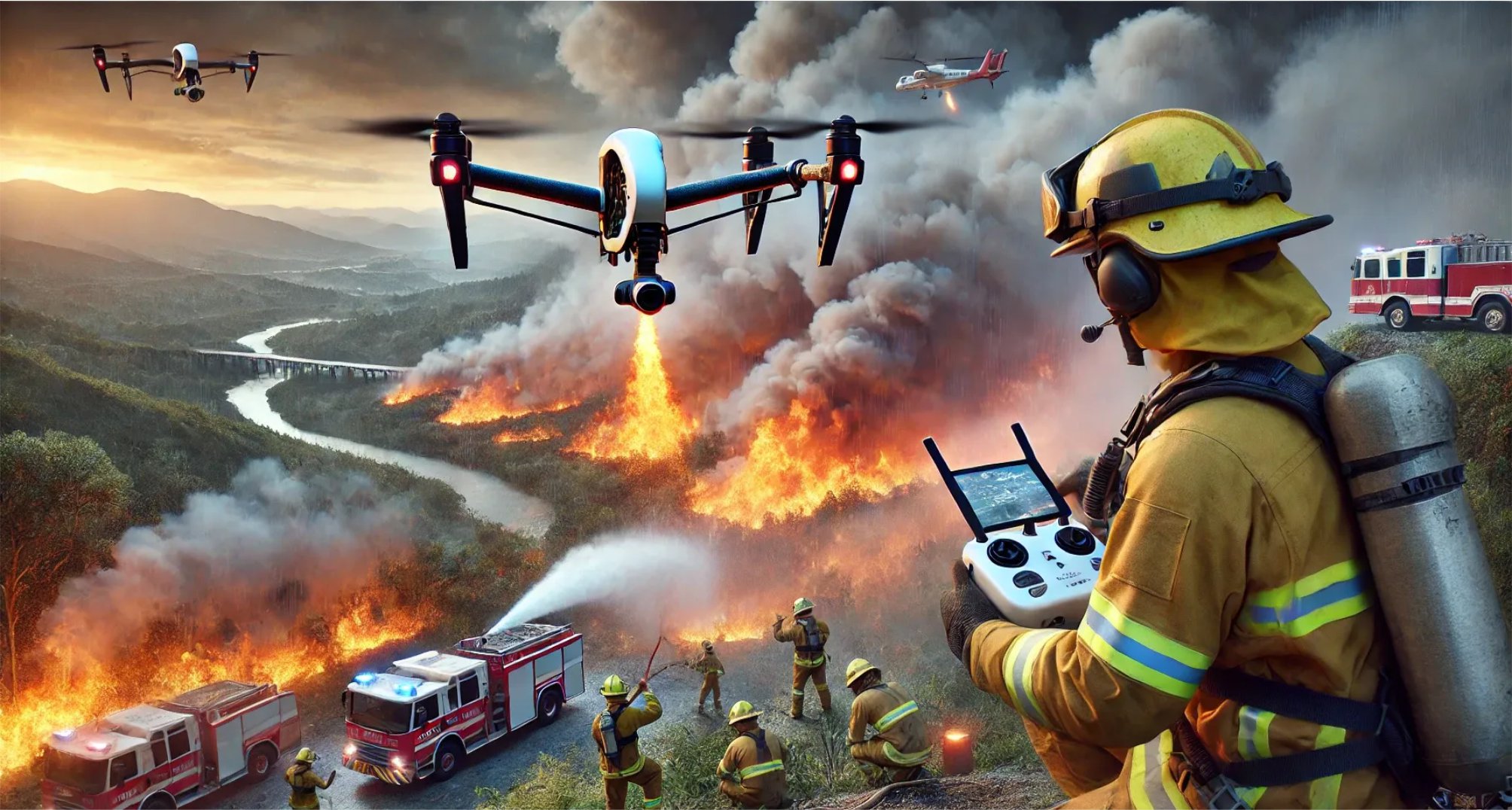
Once a wildfire breaks out, drones enter their most mission-critical phase. Equipped with thermal sensors, EO/IR payloads, and GPS-stabilized optics, drones provide real-time telemetry and visual feeds to incident command centers. UAVs can fly at low altitudes and withstand turbulent thermal drafts, allowing them to pinpoint active flame fronts, map heat signatures, and guide aerial water tankers or ground crews to critical areas. Their live feed can be integrated into geographic information systems (GIS) for enhanced coordination between command posts and on-ground responders. Moreover, drones can deploy fire retardants or fire suppressant spheres in early stages or inaccessible zones, though limited by payload constraints.
For example, fixed-wing drones such as those developed by Lockheed Martin or India’s DRDO can carry modular payloads and execute automated pathing algorithms for area saturation. In active firefighting scenarios, drone swarms—AI-coordinated groups of drones working in unison—are emerging as a new frontier. These swarms can cover multiple fire flanks, communicate wirelessly, and even collaborate with satellite imagery to triangulate fast-moving fires. For fire departments operating in dense or mountainous regions, this aerial surveillance significantly enhances response agility, reduces human risk, and ensures targeted use of water or chemical resources.
In post-fire environments, the role of drones extends into recovery, insurance validation, and ecological damage assessment. UAVs can cover hundreds of hectares in a matter of hours, capturing ultra-high-resolution images and geospatial data used to generate 3D terrain models. These models provide a detailed visual record of vegetation loss, soil degradation, and structural damage—critical inputs for insurance claims, government relief assessments, and environmental restoration planning. Furthermore, UAVs can be outfitted with chemical sensors to detect hazardous gas residues and water contamination in the aftermath of large-scale forest fires. The environmental intelligence generated by drones enables more accurate restoration strategies, from soil erosion prevention to replanting programs. In this way, drones are not just reactive tools; they are enablers of long-term environmental stewardship.
For B2B stakeholders, the operationalization of drones in wildfire management represents a unique convergence of safety, sustainability, and profitability. Drone manufacturers can innovate with more ruggedized, weather-resistant platforms designed for extreme heat and turbulent airflow. Payload system developers can build adaptive sensor kits that plug into various drone bodies, while AI software firms can create wildfire-specific analytics suites capable of predicting spread vectors and suppression outcomes.
Governments and municipal firefighting agencies, facing both budgetary constraints and rising wildfire risk, stand to gain significantly from public-private partnerships focused on drone-based fire services. From a policy perspective, establishing airspace corridors for firefighting UAVs and integrating drone operations into emergency response protocols will be critical to scaling adoption.
As India begins facing more frequent wildfires—evident in the dry belts of Uttarakhand, Himachal Pradesh, Chhattisgarh, and Odisha—the need for drone-integrated wildfire strategies becomes imperative. The Ministry of Environment, Forest and Climate Change (MoEFCC) and National Disaster Response Force (NDRF) could spearhead national drone deployment frameworks. Forest departments, through state-level funding or CSR alliances, can equip field officers with tactical drones for early detection and patrol. Simultaneously, industrial players in mining, infrastructure, and energy operating in remote forest-adjacent zones can adopt drones as part of their Environment, Health, and Safety (EHS) protocols to mitigate wildfire risks.